Santa Barbara County Plans Aerial Survey of Oak Trees
- Share via
SANTA BARBARA — An aircraft will fly over Santa Barbara County’s wine country this year, snapping photographs of sprawling oak woodlands in the picturesque countryside.
County officials hope the aerial mapping will form a comprehensive database that will help strike a balance between environmentalists who want to save the oak trees and those who want them bulldozed to make way for new vineyards.
“A lot of people in the agricultural community say that oaks are a renewable resource, so to improve their odds of regeneration it would greatly help to know where those historical woodlands were located,” said county planner Dan Gira.
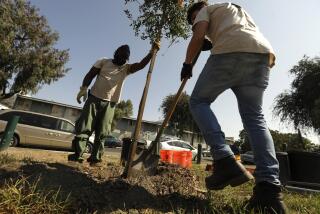
Protecting oak woodlands became an issue in November when Santa Rosa-based Kendall-Jackson removed 900 oaks for its new 600-acre Camelot vineyard near Los Alamos, about 55 miles north of Santa Barbara. A flurry of letters denouncing the project hit local newspapers.
The winery says it is sparing 90% of the trees on the 1,300-acre ranch and will plant hundreds of seedlings.
In the last two years, an estimated 2,000 oak trees have been removed for new vineyards, an analysis of past aerial mapping showed.
Oak loss, which can threaten biological diversity, is a familiar issue in some of the state’s wine regions, including San Luis Obispo, Sonoma, Lake and Mendocino counties.
Agriculturists, environmentalists and urban residents in Santa Barbara County are working together to protect oaks while promoting farmers’ flexibility to work the land.
The aerial mapping will start soon in Los Alamos Valley, and will be followed by flights over the Santa Ynez, Lompoc and Santa Maria valleys.
“It’s another tool that will provide solid information,” Gira said.
More to Read
Sign up for Essential California
The most important California stories and recommendations in your inbox every morning.
You may occasionally receive promotional content from the Los Angeles Times.


